|
Blog Feeds
Anti-Empire
The SakerA bird's eye view of the vineyard
Public InquiryInterested in maladministration. Estd. 2005
Voltaire NetworkVoltaire, international edition
|
Leinster Orbital Route Threatens Hill of Tara national |
history and heritage |
news report national |
history and heritage |
news report
 Sunday November 08, 2009 14:25 Sunday November 08, 2009 14:25 by TaraWatch by TaraWatch info at tarawatch dot org info at tarawatch dot org
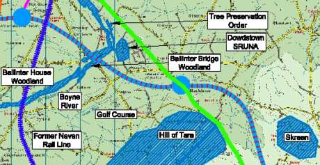
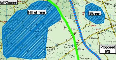
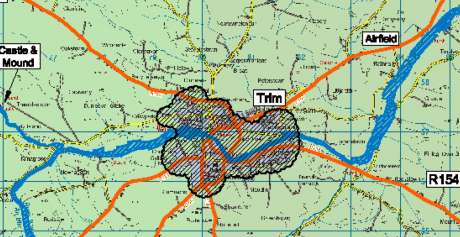
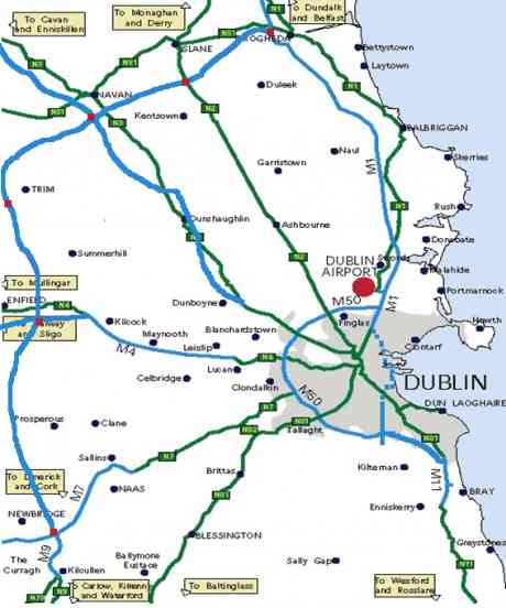
 The NRA made a presentation to Meath County Council last week about the Leinster Orbital Route, and one councillor predicted an 'uprising'' in Duleek. WIll there be one at Tara too? For years now, we have been reading about plans for the Leinster Orbital Route (LOR) or Dublin Outer Orbital Route (DOOR). Earlier this year, the NRA published a Feasibility Report from 2007, which shows route of the LOR passing along the side of the Hill of Tara. Notably, the route goes about 1km north of the Blundelstown Interchange, between the N3 and M3 motorway. However, last week Meath County Councillors were told to freeze planning on a 2km corridor on either side of the route. So, it is possible the route will pass directly through the Blundelstown Interchange, the Hill of Tara complex and the proposed UNESCO World Heritage Site. In fact, it appears that this was the plan all along, and that the route has been chosen before the public consultation even begins. The National Roads Authority (NRA) has briefed Meath County Councillors on plans for the Leinster Orbital Route (LRO) – a toll road which is proposed to run from Wicklow to County Meath, via County Kildare – and through the heart of the heritage town of Trim, as well as the Hill of Tara complex. A Feasibility Study performed by Roughan & O’Donovan – FaberMaunsell Alliance, as well as Goodbody Economic Consultants, and Tiros – Planning, Sustainable Development and Landscape Consultants, and published in March 2007.
The report describes the route in detail as follows, in 6.3.2: Passing south of Navan will require careful route planning, as it will cross the River Boyne near the edge of the urban area and not far from the Tara area, which has a sensitive landscape constraint. The route will cross the proposed M3 motorway in the vicinity of the Navan South Interchange. Provision of a junction between the two routes at this location will require careful design in conjunction with retention of the local road links that are part of the M3 scheme. Due to the other significant constraints in the area, it would be difficult to develop a fully separated junction with the M3 at sufficient separation to the north or south of the Navan junction. TRIM The town of Trim is officially designated a heritage town, of approximately 10,000, in the Meath County Development Plan. Yet, the motorway is going to pass through the middle of it. The Feasibility Report states: Between Navan and Trim the route will stay several kilometres north of the River Boyne Valley so as to avoid important cultural heritage sites and landscape constraints along the river corridor. At Trim there are two route options available. One option is to pass north and west of the town where there are no major constraints as the route crosses predominantly agricultural landscape consisting of medium to large land parcels with some value from hedgerows. Alternatively, the route could turn south and pass east of Trim, but this route would need to keep about 3km downstream of the town so as to avoid several historical sites along the banks of the River Boyne. The landscape south of Trim is predominately rolling hills and lowland. Farming consists of a mix of pastoral and arable farms. Land parcels become larger moving south away from Trim and are often of poor condition with a poor hedgerow structure. The River Boyne will again need to be crossed in a sensitive manner. Although these higher reaches are of lesser landscape value than that found in the Boyne Valley, the river is still of conservation importance. South of the river within the path of the proposed route is Doolystown Bog pNHA. The Meath Chronicle published the following article on November 4 2009: ‘Uprising’ predicted in Duleek over plans for orbital route: http://www.meathchronicle.ie/news/navan/articles/2009/1...ments PLANS for a new 80km motorway – the Leinster Orbital Route – displayed at a Meath County Council meeting this week would be greeted with “an uprising” when it was seen by the people of Duleek and East Meath, a councillor declared. The plans for the road, which would sweep from Drogheda to Slane, Navan, Trim, Kilcock, Naas and Kilcullen, are at an early planning stage and got a heavily qualified welcome from council members. However, serious doubts were raised over the need to keep a 2km-wide corridor of land open while consultations take place over the choosing of a final route for the motorway. Councillors expressed concern that extensive land masses would be sterilised and out of bounds for development while planning for the motorway went on. Doubts about the plan – shown to members by two senior National Roads Authority (NRA) officials – were raised by Cllr Jimmy Cudden who said that he had viewed them on the internet. He said that he lived in Duleek, where they already had the Irish Cement factory and an incinerator under construction, and it appeared to him that the proposed new motorway would be “squeezed in between the cement factory and the Drogheda-Navan railway line”. But most of his reservations centre on the Commons area of Duleek, “a national heritage area”, and a nearby residential estate, High Meadows. “I am very familiar with the place having driven a coach and delivered children to school from there and there is a very small space between the estate and the railway line”. “When this plan is seen by the people of East Meath and Duleek I can only envisage that there will be a total uprising on this. This proposal won’t get through”. He said that a 2001 plan for the orbital route had shown that it would “avoid the village of Duleek altogether”. In their presentation to councillors, the NRA officials Nigel O’Neill, senior project manager, Strategic Planning Unit and Hugh Creegan, head of PPP, Commercial Operations and Strategic Planning, said that the plan was supported by the regional planning guidelines, A Platform for Change, Transport 21, National Development Plan 2007-2013. There had been previous studies in 2001-2002, a feasibility study 2006/2007. It had been issued to the Department of Transport in March 2007. There had also been a recent exercise undertaken at likely junction locations to identify possible land protection to preserve viable routes. The officials were unable to give a cost for the project or project when it might get under way.They said that constraints had been mapped so as to identify potential corridors. There were also significant archaeological constraints on picking a route and there were other topographical, ecological, development and environmental constraints. In deciding the route for the motorway, there were limited options between Navan and Drogheda but more variation in route corridors south of Trim. There would also be a significant challenge in connecting with the M3 at Navan. The officials said that a feasibility study had shown that the orbital route would be beneficial for the region in terms of strengthening links between key development centres, assisting economic development and improving the overall transport network. After the study had been completed, the officials said, the recommendation of the NRA to the Department of Transport was that the scheme should be progressed to the next stage of development – the preparation of the statutory documentation for the project. Cllr Eoin Holmes said he wanted to know the status of the plan and how the “corridor” for possible routes had been chosen. He said it would be very hard for people to get their heads around the whole project and he would like to have seen a more detailed outline of the route selection process. Cllr Eugene Cassidy raised questions over the possibility of having a 2km-wide corridor preserved along an 80km route. Was it the case that no planning permission could be granted within that 2km corridor, he asked. Cllr John Farrelly said he believed that more clarity was needed about the plan. They had to be careful that they did not tie up a 2km sweep of countryside while waiting for a final route to be selected. He said that some people had been “very busy” in coming up with a number of drafts up to June 2007 (when the General Election had been held) but they had not heard anything after that from people who were making decisions about the motorway. Council chairman Bill Carey said he hoped that the people of Meath would not be left “dangling on a string” for 10 years awaiting decisions on the motorway. Cllr Joe Reilly said that what they had to do was ensure that the project was included in the National Development Plan. However, they would first have to ask if the project was actually needed. Would they not be better spending money on a public transport system, he asked. Cllr Brian Fitzgerald said, “What I can see here is a whole stretch of land in Co Meath being tied up for ever and a day”. He also asked if the road would be tolled. Cllr Tommy Reilly said that he had been shouting for 10 years about the need for an outer orbital route. The motorway would “open up the county” and bring development, a regional college, hospitals and industries. He hoped there would be a quick decision on the selection of final route. They had talked about a railway line from Navan to Dublin for 20 years and a local TD, Noel Dempsey had put up the money to get the project under way. One of the NRA officials promised councillors that when the NRA developed up the route process, they would first show it to them before putting it on display to the public. LINKS – FURTHER INFORMATION DOR Feasibility Report http://www.nra.ie/Publications/DownloadableDocumentatio...n.pdf DOR Maps http://www.nra.ie/Publications/DownloadableDocumentatio...n.pdf Department of Transport – Reply to Parliamentary Question on LOR – 28 June 2007 http://www.transport.ie/viewitem.asp?id=9570&lang=ENG&l...=2128 Department of Transport – Reply to Parliamentary Question on LOR – 12 November 2008 http://historical-debates.oireachtas.ie/D/0667/D.0667.2....html Department of Transport – First Annual Report on the Programme for Government 2007-2012 http://www.taoiseach.gov.ie/attached_files/RTF%20files/...h.rtf National Roads Authority press release ‘Business Community Warned to be Ready for 2010 or the Roads Will Pass You By! – 17 Oct 2007 http://www.nra.ie/News/PressReleases/htmltext,10779,en.html Parliamentary Debates – 17 June 2008 https://www.cahill-printers.ie/Debates/DDebate.aspx?F=D...age=5 Parliamentary Debates – Transport Committee – 1 July 2009 http://debates.oireachtas.ie/DDebate.aspx?F=TRS20090701...age=2 Trim Development Plan 2008-2014 – Chapter 7 – Infrastructure http://www.meath.ie/LocalAuthorities/Publications/Plann...n.PDF NEW STORIES Irish Independent – 15 May 2008: €2bn Navan to Newbridge orbital road ‘a top priority’ http://www.independent.ie/national-news/83642bn-navan-t....html IMAGES STATEMENT BY NRA The NRA has now placed the Leinster Orbital Route Feasibility Report onto its website for Public Information http://www.nra.ie/News/NewsAnnouncements/htmltext,16140....html Leinster Feasibility Report The National Roads Authority was charged by Government with the task of carrying out a Feasibility Study in respect of a possible Leinster Orbital Route (formerly known as the Dublin Outer Orbital Route). The conclusion of the work undertaken has been the identification of a corridor linking Drogheda to Navan to Naas as being the corridor that most closely reflects the ambitions set out in the various policy documents for the region and that best achieves the outcomes required from such a route. The attached document provides an examination of the feasibility of the identified project from a policy, economic, engineering and environmental perspective. Its conclusions can be summarised as: 1. The route is strategically beneficial for the region in terms of strengthening the links between key development centres, assisting the economic development of this centres and improving the overall regional transport network; 2. The route is economically viable. The work done to date indicates that the benefits of the project are significantly greater than the project costs; and 3. The route is technically feasible. While there are numerous constraints throughout the corridor area and adjacent to the corridor, it has been identified that a proper and satisfactory alignment can be developed to deliver the project. In addition, while there are environmental challenges to be addressed there are no environmental issues that would rule out this alignment at this stage of the process. Arising from the favorable conclusions of the Feasibility Study Report, the Authority recommends that the scheme, which has been retitled as the “Leinster Orbital Route” to reflect the positive impacts of the scheme extending well beyond Dublin, be progressed to the next stage of development – the preparation of the statutory documentation for the project. This would ensure that the scheme would remain protected and would be ready and available for implementation at any stage in the future, when required. In addition, it would prevent new constraints from emerging that would render the project unavailable, or significantly increase its costs, in the future. |


 printable version

 Digg this
 del.icio.us
 Furl
Furl Reddit
 Technorati
 Facebook
 Gab
Gab Twitter
View Comments Titles Only
save preference
Comments (9 of 9)
Jump To Comment: 1 2 3 4 5 6 7 8 9This plan doesn't even make economic sense, as it makes a mess of heritage sites that draw tourists from Ireland, UK, & places farther afield.
I cannot believe that they are planning this. In a recession when traffic is down, when oil production has peaked and motor transport will never again reach the volume of the early 21st century. What an unbelievable waste of money and act of destruction.
DOR [asses through the heart of the small town of Trim, passing even through the old town walls.
Chapter 5 of the Trim City Development Plan 2008-2014, entitled 'Built and Natural Heritage, states:
Trim has a rich history dating back many centuries from which we are fortunate to have inherited many structures and monuments of great heritage value. The town also has many natural heritage features to offer residents and visitors alike, with the River Boyne and its associated candidate Special Area of Conservation located in the heart of the town. The Trim Wetland pNHA is located east of the town at the bend in the Boyne at Scurlockstown. However conservation of the town‘s heritage resources is a complex issue due to the need to achieve balance between the conservation of the town‘s indispensable heritage and the facilitation of necessary development to serve the present and future population of the town. In order to fully appreciate this, full understanding of its historical development and its changing nature, function, and form is critical.
The Planning and Development Act 2000, Section 10 (2), as amended, outlines the mandatory objectives in respect of built and natural heritage in development plan preparation. These are as follows:
The conservation and protection of the environment, including in particular the archaeological and natural heritage and the conservation and protection of European sites and any other sites which may be prescribed for the purposes of this paragraph;
The protection of structures, or parts of structures, which are of special architectural, historical, archaeological, artistic, cultural, scientific, social or technical interest;
The preservation of the character of Architectural Conservation Areas, and;
The preservation of the character of the landscape, where and to the extent that, in the opinion of the planning authority, the proper planning and sustainable development of the area requires it, including preservation of views and prospects and the amenities of places and features of natural beauty or interest.
Meath Heritage Town - Trim
http://www.heritageisland.com/attractions/trim-heritage...town/
Fierce Vikings, fleeing monks and fighting lords – it’s no wonder that the makers of the movie ‘Braveheart’ chose Trim as the shooting location for their epic thriller. One look at Trim Castle and story book images of valiant warriors and timid monks spring to life - why not visit them in the ‘Power & Glory Audio-Visual Show’ and see the Braveheart filmset model. Trim – a Heritage Town in the heart of the country – but less than one hour from Dublin. Dominated by the majestic 12th Century Castle (Euro Nostra Award Winner 2003 and the largest Anglo-Norman Castle in Europe) and the mystical River Boyne, Trim provides visitors the ultimate in relaxation or the thrill of action. Trim is now a prosperous and busy market town. Visitors are offered heritage tours, cycling, fishing, swimming, golf, tennis, canoeing, musicals, drama festivals, vintage rallies, traditional music, medieval festivals, agricultural shows – all you could wish for in a picturesque setting. The Ramparts Coffee Shop offering high quality home-made food is also available at the visitor centre.
Heritage Towns Ireland - Trim
http://www.heritagetowns.com/trim.shtml
Trim is dominated by the greatest treasury of medieval monuments in Ireland. Prime among them is Trim Castle, the largest Anglo-Norman Castle in Ireland, which was used as a location in the film 'Braveheart'. Steeped in history, Trim also played a part in shaping the lives of such historic figures as the Duke of Wellington and Dean Jonathan Swift. Trim is now a prosperous and busy market town. Close by is the Visitor Centre where chronicles, knights and kings emerge through the mists of time in an exciting multi-media show. High quality local craft work is also available.
In 1991 the Heritage Town Programme emerged in the context of the similar Theme Town Scheme, which had operated successfully in the United Kingdom. 30 Irish towns were chosen from over 600 submissions. These towns were chosen for their unique heritage resources and potential to achieve tourism development and growth given Heritage Town status. The principle of the scheme was that a number of towns with a strong physical heritage would be developed as being representative of the heritage of Ireland. This development would have the two-fold effect of helping to protect the built environment and providing a marketing tool for the tourism industry in those towns and the country at large. In line with the proposals set out in The 1994 Bord Failte Document 'The Heritage Town Concept' development in the designated towns included:
* Opening conserved historic buildings to visitors.
* Devising a number of themes including historic, architectural, archaeological, literary, religious linking individual points of interest.
* Devising an integrated signage system.
* Developing an integrated traffic management plan incorporating car parking and pedestrian routes.
* Developing and managing a Heritage Centre.
The core part of the Heritage Town Programme was the development of a Visitor Centre. This Heritage Centre would provide an orientation point, a gathering place and an information centre for the project. The support for Heritage Towns was given by the Government in their effort to decentralise tourism.
LINKS
Trim City Development Plan 2008-2014 documents:
http://www.meath.ie/LocalAuthorities/Publications/Plann...2014/
Trim Castle, A Monument to Bad Planning?
http://www.publicinquiry.ie/reports.php
The first report by the Centre for Public Inquiry concerns the decision by the local authority in County Meath to permit the construction of a four storey hotel beside Trim Castle, one of Ireland's most important national monuments. The report is the result of complaints to this office by elected representatives in County Meath and concerned citizens including members of the heritage protection organisation, An Taisce. The investigation raises several issues of significant public concern which are outlined in detail in the following pages. The report has been made available to the Minister for the Environment, Heritage and Local Government, Dick Roche, members of the Oireachtas and of the relevant local authorities as well as to a large number of interested parties including the people of Trim.
Before
After
Town walls to be bissected by motorway
Meath Heritage Trail (of destruction)
We need another public enquiry
none of the info posted by anybody on this thread offers any concrete proof that the LOR will cut through Trim. The NRA might be up to all sorts of shit but it certainly hasn't briefed Meath County Councillors on the road running 'through the heart of the heritage town of Trim' because, errrr, it won't. Look at the maps you've posted yourselves...
And as for 'Trim to be decimated by motorway'...
By posting stuff here that just isn't true you're completely wrecking a perfectly valid argument against the LOR.
Hi em AA, Is there some reason you are ignoring the blue line, symbolising the route of the road, going through the centre of the town?
I think you'll find that the blue line represents the river Boyne.
LOL! Best smackdown ever!
News headline: "Anti-road lobby group mistakes river for motorway"
I will save the commenters here further embarrassment by moving swiftly on.
I drew the map linked below based on the NRA's detailed description of the route. The one posted by the OP is wrong and based on an early alignment. The motorway can clearly be seen to avoid *everything* along the route - towns and heritage sites alike. There will be no negative impacts.
Trim: Motorway passes 2km from the town centre.
Tara: Motorway passes nearly 7km from the hills of Tara and Skryne.
Newgrange: Motorway passes 5km from the sites.
@Ian: The "end of oil"? What does that have to do with traffic? Everyone will just be driving electric cars. Green energy will remove the negative environmental aspects of driving and road building will continue at a rapid pace. Traffic levels will be much higher in the future than they are now.
And '...road building will continue at a rapid pace...'
Aside from the minor detail of where all that green energy will be sourced (more of the infinite growth from finite resources mirage and there should be another techno-fix along any minit, ask BP), when all that road to nowhere at a rapid pace building has concreted the island from sea to shining sea, whats the second stage of your NRA /CRH pipedream? Go up in tiers till you hit fresh air?Plug in your brain Pippin, it grows late.
Automobility is not the crown of evolutionary achievement, despite what your showroom flannel-merchant has sold you as compensation and consolation for your cerebral poverty. The blind consumptive society must pass, one way or the other. Either we wake up and dismantle it, or the inherent logic of its trajectory will will strip-mine the earth. The latter gets the better odds. Green energy is big oil's carrot to keep the donkey shafted, while it adjusts its next mechanical solution to biological collapse.You are literate.Read the science and lose that infantile 'Faith'. It is human(actually simian, pre-human, to be more precise)behaviour needs changing, not just the fuel that feeds our mode of loco-motion.
"I think you'll find that the blue line represents the river Boyne."
The Boyne was a Superhighway in ancient times.
Hopefully the protesters won't try to block it up now.